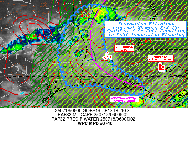
Mesoscale Precipitation Discussion 0740
NWS Weather Prediction Center College Park MD
417 AM EDT Fri Jul 18 2025

Areas affected...Western & Southwestern LA...Southeast Texas...

Concerning...Heavy rainfall...Flash flooding possible

Valid 180815Z - 181400Z

SUMMARY...Western band of compact tropical vorticity center (93L).
 Shallow but highly efficient rainfall production with rates of
2-3"/hr and back-building potential for repeating.  Focused
spots/streets of 3-5" & rapid inundation flooding possible.

DISCUSSION...Early morning diurnal peak of weak capping is
starting to provide destabilization dividends along the western
downshear DPVA, low to mid-level convergence band of tropical
system 93L.  The overall system remains vertically sheared with
surface wave back near Baton Rouge toward Lake Pontchartrain;
though 700-500mb center is further west and is very well defined
in SWIR/EIR GOES-E Loops near Allen Parish.  A slight eastward
wobble to the circulation has also tightened the 850-500mb flow
with solid downshear convergence tapping the weakly capped air in
a hemispheric arc from just east of Shreveport to Jasper county
before angling southeast past Lake Charles toward Marsh Island.
Skinny moist profiles due support slow updraft speeds but solid
directional and weak speed convergence along the band is tapping
the 1500-2000 J/kg of available MUCAPE; but it is the available
moisture around 2.5", loaded in the sfc-700mb layer per CIRA LPW
that will provide efficient warm cloud processes to support
2-3"/hr rates even with the weaker updraft strength.

The concern is the potential for stronger inflow to maintain a
favorable back-building/regenerative upwind edge to convective
elements as they rotate west and southwest along the band, with
near zero cell motions along the southwest portion of the
700-500mb low and along the southern periphery of the circulation.
Currently, best convergence appears to be along/just off shore of
Cameron parish, but any small northward displacements could result
in sizable increase in rainfall totals.  As such, best overlap of
elements prefers SW LA and along the Sabine River into Far SE TX
over the next 4-6hrs; with isolated totals of 3-5" possible with
intermittent passage of cores; inundation flooding is considered
possible.

Gallina

ATTN...WFO...LCH...SHV...

ATTN...RFC...FWR...ORN...NWC...

LAT...LON   32599302 32429280 32149285 31539301 31019291
            30559273 30149225 29839165 29509144 29379162
            29469212 29729320 29699416 30229443 30829455
            31249447 31979419 32519371
Download in GIS format: Shapefile
| KML
Last Updated: 417 AM EDT Fri Jul 18 2025
| 


